Welcome to the NERACOOS Graphing and Download Tool!

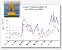
Weather and sea condition data are collected from buoys in the northeast.

These pages are designed to help you access the collected data in order to enhance your work, study or play!

 
View the following types of data:
  • air temperatures
  • water temperatures
  • wind direction & speed
  • wave heights
  • salinity
  • ... and many more!
Output your data to:
  • text files (CSV)
    (best for import into MS Excel spreadsheets)
  • html tables
  • graphs
Let's get started... 
If you are having problems with Graphing & Download, click here.
Data accessed through Graphing and Download is REALTIME data. For NERACOOS Buoy Historical Data (Realtime qc'd with Post-Recovery) see the Gulf of Maine Moored Buoy Program or use our OPeNDAP Server.